The highlight of our Spring 2018 Cub Scout Campout was hiking along the Appalachian Trail and seeing the very first Washington Monument. We camped at the Washington Monument State Park in Middletown, Maryland, not on the Mall in the District of Columbia.
The Appalachian National Scenic Trail runs over 2000 miles from Maine to Georgia. The idea of a footpath through the Appalachian Mountains began in 1921 and the trail was completed in 1937. It was the work of private citizens but is now maintained by a conglomeration of the National Parks Service, US Forest Service, the Appalachian Trail Conservancy, numerous state and local agencies, and many volunteers. The Trail was across the drive from our campground, so we looked both ways before we got to the trail.
Our hike leader explained how rain bars were put along the trail to keep rainwater from washing out the trail or turning it into a miniature Grand Canyon. We saw plenty of wooden and stone examples of how volunteers made sure the trail stayed trail-like.
Further up the hill, we discovered a sign marking the trail. I like how the A and T are blended to mark the trail. It looks almost like an arrow head pointing travelers in the right direction. The sign also lets hikers know they can stay overnight nearby.
The trail in this park also has some substantial shelters for hikers, presumably to get out of the rain or have a meal that isn't on the ground.
Since this part of the trail led up to the monument, eventually it forked. We turned left and went off the trail.
From here, the walk up to the monument was fairly short. The monument was built in 1827 by the residents of Boonsboro, who met in the town square on the Fourth of July. They climbed the hill and worked till noon when they had lunch and a dedication ceremony. By 4 p.m., the monument was fifteen feet high. They read the Declaration of Independence and some Revolutionary War veterans fired a three-gun salute. The townsfolk returned in September to finish the monument. It now stands 30 feet tall.
We were happy to see we could climb up inside and take in the view from the top. Historically, the monument was used as a lookout during the American Civil War. It has an excellent view of Hagerstown, West Virginia, and the Antietam Battlefield.
The trip back down the monument was a little more harrowing for me, just because these types of windy stairs always seem steeper and more perilous going down rather than going up.
A small plaza sits in front of the monument giving another view of the valley, though not as good.
The hike leader gave the boys the option of returning to the campgrounds or hiking further along the trail. They all opted to go back but my daughter wanted to continue on, so she and I forged ahead.
The trail was sloped and rocky but not too challenging. We saw plenty of stones in the area and wondered if the Boonsboro people chose here because the building materials were so conveniently available. Or maybe they hauled all the rocks up the hill and left a lot of unsatisfactory ones aside.
We came to a part of the trail where a set of power lines cut across. We wondered if hikers could recharge their electronics. The poles had no outlets on them, so I guess hikers had to make it to the state park buildings if they needed to amp up.
We decided to head back at this point. The trail back to the monument was definitely uphill.
Later in the day, we had some free time and my daughter wanted to walk the trail in the other direction from the campsite. We headed south along a much smoother and flatter path.
Amazingly enough, we ran into different power lines! These brought electricity into the park as well as providing power to the local residents.
On the way back to camp, we saw another cool Appalachian Trail marker.
We were inspired enough to get some books out of the library about the trail. We may try to hike more of it in the future. Maybe when the preschooler is bigger.
The Appalachian National Scenic Trail runs over 2000 miles from Maine to Georgia. The idea of a footpath through the Appalachian Mountains began in 1921 and the trail was completed in 1937. It was the work of private citizens but is now maintained by a conglomeration of the National Parks Service, US Forest Service, the Appalachian Trail Conservancy, numerous state and local agencies, and many volunteers. The Trail was across the drive from our campground, so we looked both ways before we got to the trail.
 |
| Starting the hike |
 |
| First part of the trail |
Our hike leader explained how rain bars were put along the trail to keep rainwater from washing out the trail or turning it into a miniature Grand Canyon. We saw plenty of wooden and stone examples of how volunteers made sure the trail stayed trail-like.
 |
| Wooden rain bar |
Further up the hill, we discovered a sign marking the trail. I like how the A and T are blended to mark the trail. It looks almost like an arrow head pointing travelers in the right direction. The sign also lets hikers know they can stay overnight nearby.
 |
| My son by the sign |
The trail in this park also has some substantial shelters for hikers, presumably to get out of the rain or have a meal that isn't on the ground.
 |
| Shelter named after Mount Vernon! |
Since this part of the trail led up to the monument, eventually it forked. We turned left and went off the trail.
 |
| Not following this sign |
From here, the walk up to the monument was fairly short. The monument was built in 1827 by the residents of Boonsboro, who met in the town square on the Fourth of July. They climbed the hill and worked till noon when they had lunch and a dedication ceremony. By 4 p.m., the monument was fifteen feet high. They read the Declaration of Independence and some Revolutionary War veterans fired a three-gun salute. The townsfolk returned in September to finish the monument. It now stands 30 feet tall.
 |
| The first Washington Monument |
We were happy to see we could climb up inside and take in the view from the top. Historically, the monument was used as a lookout during the American Civil War. It has an excellent view of Hagerstown, West Virginia, and the Antietam Battlefield.
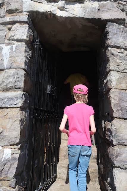 |
| Dark doorway |
 |
| Daughter and son at the top |
 |
| View of the valley |
 |
| Zooming doesn't give much more detail |
 |
| Looking north toward Hagerstown |
 |
| More beautiful hillsides |
The trip back down the monument was a little more harrowing for me, just because these types of windy stairs always seem steeper and more perilous going down rather than going up.
 |
| Stairway down |
A small plaza sits in front of the monument giving another view of the valley, though not as good.
 |
| The monument from the front |
 |
| Valley view |
 |
| Maryland flag and my two children |
The hike leader gave the boys the option of returning to the campgrounds or hiking further along the trail. They all opted to go back but my daughter wanted to continue on, so she and I forged ahead.
 |
| Happy to get more trail in |
The trail was sloped and rocky but not too challenging. We saw plenty of stones in the area and wondered if the Boonsboro people chose here because the building materials were so conveniently available. Or maybe they hauled all the rocks up the hill and left a lot of unsatisfactory ones aside.
 |
| More trail |
 |
| More rocks |
 |
| A tree over the trail |
We came to a part of the trail where a set of power lines cut across. We wondered if hikers could recharge their electronics. The poles had no outlets on them, so I guess hikers had to make it to the state park buildings if they needed to amp up.
 |
| Power lines! |
 |
| Not the Appalachian Trail |
 |
| The other direction |
We decided to head back at this point. The trail back to the monument was definitely uphill.
 |
| The way back |
Later in the day, we had some free time and my daughter wanted to walk the trail in the other direction from the campsite. We headed south along a much smoother and flatter path.
 |
| Trail going south |
 |
| Split trees |
 |
| Smaller rocks |
Amazingly enough, we ran into different power lines! These brought electricity into the park as well as providing power to the local residents.
 |
| More power lines! |
 |
| Why did the trail cross the road? |
On the way back to camp, we saw another cool Appalachian Trail marker.
 |
| AT in a tree! |
We were inspired enough to get some books out of the library about the trail. We may try to hike more of it in the future. Maybe when the preschooler is bigger.


No comments:
Post a Comment